Category: Mapping
-
EVENT: 3/1/13 – 3/9/13 Occupy Data Hackathon and Exhibit
What: Occupy Data Hackathon and Exhibit (focus will be on Occupy Sandy Data) Cost: Free (please register to attend Hackathon) When: Hackathon: Mar 1, 2013 to Mar 2, 2013, 12:00pm-6:00pm each day Exhibit open to the public: Mar 5, 2013 to Mar 9, 2013, Tue-Thu 12-7pm and Fri-Sat 12-6pm Where: The James Gallery The Graduate Center,…
-
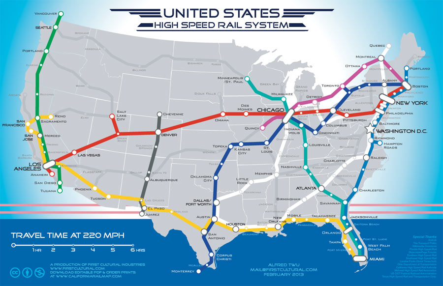
The Map That Could Fast Track Plans For High-Speed Rail
You might have seen it on social media somewhere, but in case you haven’t heard of it, Berkeley-based artist and high-speed rail advocate Alfred Twu recently posted a map he created on the Guardian’s website (the map was originally featured on the California Rail Map google group, where additional resources on high-speed rail are listed). It’s…
-

PlowNYC Map
New map tracking snow plows now available from the city!
-

Revisit Paris and New York, Courtesy of Airpano from Russia
AirPano Several photography buffs from Moscow started to photograph the famous monuments and cities with a 360 degree panoramic camera mounted on a small radio controlled helicopter like device. These high-resolution films of the cities taken from a height of 50 to 250 meter are amazing to see. Their panoramic views provide a detailed context to these monuments which is hard to get through a…
-
Historical Hurricane Data
I have been looking around the internet at how hurricane data over time is shared and visualized and wanted to share some of what I came across… The National Oceanic and Atmospheric Administration (NOAA) is typically the go to place for Americans and many others for any hurricane data. They happen to have an…
-
Hurricane Sandy – A picture (map) is worth a thousand words.
Hurricanes and cyclones are global weather events which require the mapping capabilities of weather satellites. The National Oceanic and Atmospheric Administration (NOAA) is a federal agency focused on the condition of the oceans and the atmosphere. National Weather Service is part of the NOAA and it keeps track of hurricane activity on both coasts of the United…