
New York City’s subway network was designed for speed. It was purposefully built near the surface, along major transportation corridors, not only in order to lower costs, but in order to ease congestion on the street, and allow for quick access to stations. Unlike newer sections of the subway, dug deep underground in order to satisfy street-level NIMBYists, the original subways sacrificed short-term for long-term, 24/7 convenience. Trunk routes were built with three or four tracks, not only to increase capacity, but to increase speed. If they only wanted to increase capacity, the express tracks would just be additional local tracks, and would also stop at every station.
The city’s grid system was also designed for efficiency, which would later translate to greater speed underground, on a series of subway trunk routes, built straight, without much need for eminent domain. While progressives quickly lament Robert Moses’ highways, they’re less quick to realize that New York’s streets are also a product of urban renewal (or the streets of Paris, Boston’s Back Bay, and so on, so forth). Unlike Lower Manhattan’s streets, the portion of the City designed for the grid was already replete with houses, many of which were completely obliterated by the grid’s monotonous efficiency. Lots were razed, leveled, bisected, and subdivided, turning Manhattan, named as such from Manahatta, the Lenape word for an island of many hills, into a flat, efficient, business hub of the world.
The grid maximized the potential of the island, while destroying most of the hills, valleys, forests, and streams. Surveying was an immense task, and it wasn’t easy to continue with such a massive, controversial plan, which sometimes turned violent, when owners realized their land was going to be destroyed. Ultimately, though, NIMBYism did not prevail.
The City acquired land and compensated owners, and then owners helped to pay for the City’s pavement, similar to how developers today often contribute funds for transit improvements, in exchange for receiving a building permit, based on assessed values. Developers also built avenues themselves, such as Lexington Avenue, which was not part of the original plan. There were to be more avenues near the shores of Manhattan, because the designers didn’t foresee containerization and assumed that business would be concentrated along the docks. The city also expanded outwards, with landfill (partly from subway construction) expanding Manhattan and surrounding islands; an artificial island was even created due from Steinway Tunnel construction.
These visionary leaders recognized that New York was growing, and that speed would be necessary in order for the region to remain connected. Today, with bus ridership declining, leaders are once again looking to improve speed (and reduce bunching).
Courtesy of the TransitCenter:
A new report urges a comprehensive reworking of the city’s bus network.
In 2002, New York City Transit recorded some substantial bus ridership numbers as 762 million people paid to ride the bus. It’s been all downhill since then, as only 650 million people used buses last year. Meanwhile, over the same period of time, New York City’s subway ridership has grown from 1.413 billion rides to 1.762 billion last year, and the population of the city has grown by around five percent. When it comes to buses, something isn’t working.
This isn’t, of course, a new development. A few weeks ago, a NYC DOT report showed how slow travel speeds, among other issues, has led to less reliable and less popular bus service, and we’ve seen how some fairly minor enhancements to bus service — dedicated lanes and pre-board fare payment — can reduce travel times. Now, a coalition of transit advocates and New York City politicians are putting pressure on both the city and MTA to do something to improve bus service and prioritize the bus network.
In a report issued last week called “Turnaround: Fixing New York City’s Buses” [pdf], the Transit Center, Riders Alliance, Straphangers Campaign and Tri-State Transportation Campaign have called for a redesigned bus network with service enhancements and best-in-class infrastructure including pre-board fare payment and dedicated street space. It’s almost revolutionary for New York but standard practice the world over. Full-scale implementation should combat the causes that have depressed bus ridership over the past decade and a half, but it will take a multi-agency effort across city and state agencies to see through.
The decline in bus ridership over the past 14 years highlights the flaws in the city’s approach to building a bus network.
Tabitha Decker, Transit Center’s NYC Program Director, summed up the recommendations. “Many of New York’s global peers, such as London and Seoul, have turned around bus systems that were in decline, even though these cities have large-scale urban rail too. They have done this by making bus travel fast, frequent, and reliable using tools like smart card based fare payment and the use of real time data to keep buses on schedule.”
The recommendations are broken down into segments. First, the report urges redesigning the bus network for more frequent and efficient service. Today’s bus network is a relic of New York City’s old streetcars, and the routes are often twisting and turning paths that end at borough borders rather than a transit hubs or other popular destinations. The coalition wants to straighten out routes for faster travel times and, as the report states, “rightsize the distance between bus stops. New York is a global outlier in terms of how closely stops are spaced, and on many routes, stops are even closer together than our own standards dictate. Optimizing the number of stops will speed trips for riders.”
The second section focuses on fare payment and boarding. Obviously, a tap-and-go system will significantly reduce boarding times if a pre-board fare payment system for all local buses is too costly. All-door boarding would reduce station dwell times as well. (The Riders Alliance recently issued a different report raising concerns with the MTA’s next-generation fare payment plans that could have ramifications for buses as well.) Continued investment in low-floor buses should improve the boarding process as well, the report noted.
Next, the report urges the MTA to change the way it dispatches and controls buses that are en route to ensure buses arrive on schedule and avoid bus bunching. In addition to dispatching buses on time, the MTA should hold buses en route to improve service. This is a bit of a controversial recommendation as it could lead to delays for passengers during their travels, but the coalition feels a more proactive, headway-based control process should improve service for everyone.
Dedicated lanes and signal prioritization can help speed up the city’s notorious slow buses.
Finally, in a recommendation that would overhaul the way buses interact with the streets, the report urges a massive expansion of dedicated lanes, a renewed focus on bus bulbs and boarding islands to “eliminate time spent weaving in and out of traffic,” signal prioritization and queue-jump lanes for buses. These changes would require DOT and the MTA to collaborate and would likely require authorization from Albany as well. It’s politically tricky but not impossible.
And yet, while an expansive coalition of New York City politics voiced their support for these bus turnarounds, Gov. Andrew Cuomo, the Grand Poobah of New York State politics, in comments to Politico New York, dismissed bus problems with a wave of his hand a complete lack of understanding. “If people in Manhattan are choosing to jump on the subway because the subway is faster, because there’s traffic that a bus has to deal with — that’s not an imprudent choice, right?” Cuomo said.
Cuomo, who thinks a USB charging port on a bus is some form of revolutionary improvement, doesn’t seem to understand the role the bus network could play in New York City, and Ben Fried took it too him in a post on Streetsblog last week. Cuomo’s Manhattan-centric view of travel speeds betrays his belief that traffic is a force of nature that cannot be addressed through rational policies and that buses mirror subways. As Fried writes, “The governor’s theory about people ditching the bus for the train simply doesn’t apply to the vast number of New Yorkers who ride these routes [that cover territory that the subway does not] and would benefit enormously from the recommendations in the Bus Turnaround report.”
In response to the report, the MTA noted that it is in the process of implementing some of these upgrades and that the agency has undertaken certain studies regarding specific routes. But overall, the MTA, DOT and city and state officials need to engage in a concerted effort to reroute and redraw bus routes while improving the infrastructure upon which buses rely. If they don’t, ridership will continue to decline, and buses will forever remain stuck with the stigma of being a second-class transportation option.
While we’ve only received one new subway station in the past few decades, our roads have been dramatically altered with bike lanes and bus lanes, and more are coming. Due to the city’s density and mass transit options, car ownership is relatively low for an American city, so bus lanes are more politically possible than in other U.S. cities, though, still not as politically popular as they’re in developing countries. (At the same time, car ownership is a tremendous status symbol in developing countries.)
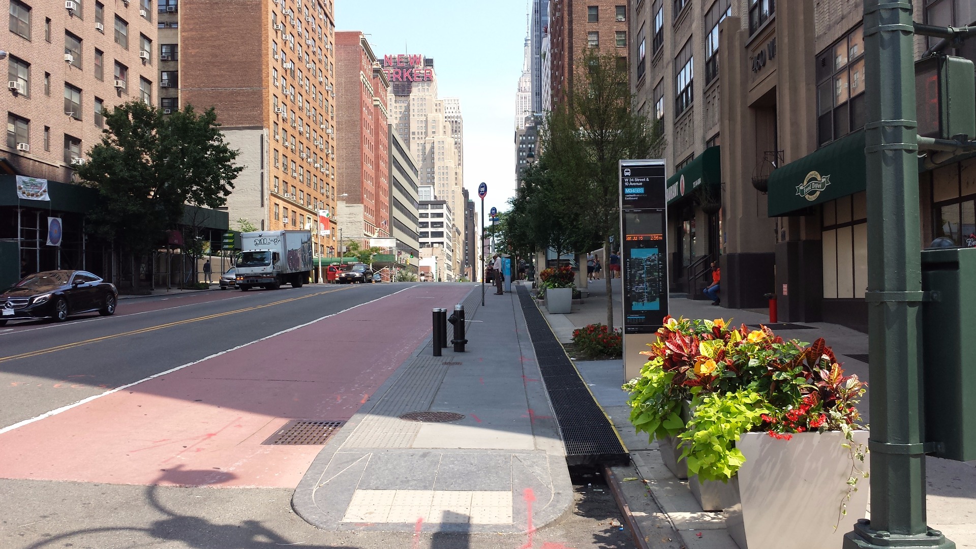
SBS, which has recently come to the rebranded Q70 to LaGuardia, has its own, separate stops, and pre-board payment, in order to ease boarding. Sidewalks are extended towards the bus lane at raised SBS platforms, so that sidewalks are less congested, and so that buses don’t have to turn into the parking lane in order to pick up and drop off passengers. Local buses don’t stop at SBS stops because it would lead to congestion, and SBS stops have bus shelters (paid for by advertisements, similar to P3 ads on garbage cans, newsstands, LinkNYC, and CitiBike), bus countdown clocks, frequency information, and way-finding maps, showing the locations of subway lines.
SBS is a big improvement, and it’s certainly better than many American cities’ bus rapid transit systems. There are actually BRT standards, and the American city with the best BRT is Cleveland’s RTA HealthLine, but other countries tend to have better BRT networks. In Cleveland, the HealthLine runs along the center of the road, so that the limited number of parked vehicles along the curb don’t interfere with the bus lane. The bus stops are on the median of the road, accessible through crosswalks, and doors open on the left, to stations along the median strip. There’s little space for parking along the road, and the buses get signal priority.

.
Meanwhile, in Pittsburgh, buses have their own separate roads, and in Ottawa, there is an intensive BRT network, with entirely separated lanes, even highways, for buses and emergency vehicles. While it doesn’t have pre-board payment or bicycle racks, it does have English and French announcements. In Sydney, bus lanes are also HOV lanes, and in Melbourne, which has the largest tramway network in the world, they run along the center of the road, akin to BRT standards. (BRT in Las Vegas also runs along the center of the road, in dedicated lanes.)


.
And in other countries, such as Ecuador, Quito’s BRT travels along roads that go underneath major intersections, avoiding traffic lights altogether. These are also articulated buses; double decker buses aren’t as good for speed because people have to climb stairs, leading to longer dwells.


.
Unfortunately though, many supposedly bus rapid transit routes aren’t rapid at all. In Boston, the Silver Line from Logan Airport to South Station is free (Massport pays the MBTA), but the Silver Line along Washington Street has no pre-board payment infrastructure, and the bus lane is along the side of the street, so it has to deal with parking cars and turning vehicles. Also, these offset lanes are not enforced well, leading to a lot of double parking and stopping. The Silver Line along Washington Street should not be shown on the T’s subway map, since it’s just a regular bus with a bus lane along the side of Washington Street.


.
And some of the MBTA Green Line routes on the street, such as the E, don’t even have separated lanes. These streetcars operate in the same lanes as vehicles, and without signal priority or pre-board payment, some portions of the Green Line are worse than the Silver Line, which at least has a bus lane. Also, if one of these streetcars fails, traffic is halted, and unlike buses, streetcars can’t swerve around the problem.

.
Then there’s the Ashmont-Mattapan Line, which can’t be operated with newer light rail vehicles because the bridges on the old railroad ROW would collapse under the weight. Perhaps they can tear up the tracks and build a bus corridor. After all, it is quite expensive to maintain these old PCC cars and ridership is so low that a bus corridor would be more efficient.

.
While the Silver Line on Washington Street shouldn’t be shown on the T’s map, since it’s just a normal bus line, New York’s SBS routes should be shown. SBS does not use the center lane either, so it runs slower, but at least they have pre-board payment machines and proof-of-payment, and level boarding to speed up entry. Passengers can enter through any door, leading to shorter dwell times.


.
Also, most of New York’s SBS routes don’t have parked cars along the side of the street because they are curbside bus lanes, and parking and standing at the curb are not permitted during hours that the bus lane is in effect. And when a new payment card is rolled out, these pre-board machines will be removed, freeing space on the sidewalk, because hopefully the card will allow for customers to tap on/off on the bus, and proof of payment would be shown by someone scanning cards to see that it’s been activated on the bus. Ideally, a universal payment method will one day work for the parking meters, ferries, light rail, taxis, buses, subways, and commuter rails. This would allow for a more seamless, speedy trip throughout the region.

.
(And if commuter rails have tap on and tap off technology at stations within the City and closest to the City, then projects like Penn Access would make more sense, because conductors often don’t have time to check everyone’s tickets so close to the terminals. Proof-of-payment and random inspections would make it easier for commuters to take the Metro-North to Yankee Stadium, or LIRR to the US Open, or to other nearby stations, such as 125th, where passengers aren’t allowed to disembark because there’s no time to check them from GCT. NJT already has turnstiles at Secaucus Junction, on the upper platform, because conductors don’t have enough time to check everyone’s tickets from Penn Station.)


.
For now, with the MetroCard, the sidewalk machines are a bit inconvenient, because unlike the City’s new parking meters, debit cards cannot be used in order to minimize transaction fees. Only exact change can be used, and dollar bills cannot be used (nor can they be used on local buses), since it’s expensive to count them. Of course, it makes sense that larger bills cannot be used, because the MTA doesn’t want thousands of dollars sitting on the sidewalks. And exact change is required because it is expensive to return change, and because, on local buses, exact change is also required. (Prior to 1969, exact change wasn’t required, but NYCT realized that there would be fewer robberies, and service would also be sped up if drivers weren’t distracted by providing change. Phone booths didn’t give out change, so why did air conditioned buses need to give out change?)
Also, if the bus is at the stop, one needs to pay before boarding, and if there’s a line, one’ll miss the bus. Some systems have similar machines inside the buses or trams, through all doors, such as in Toronto, Amsterdam, and Berlin, but this causes crowding inside the buses, and machines take away capacity. (In Sao Paulo, there are actually turnstiles in the buses, and a conductor to collect payment, while in Hanoi, there are no turnstiles or machines, and a conductor collects cash.) So, for now, these SBS machines will need to be on the sidewalks, until a new card technology is implemented. It’s especially inconvenient on Staten Island, where there are only a few official MTA vending machines, so most people buy their cards from merchants, who don’t charge a fee, but receive a commission.


.
If New York wants to continue to improve buses, WiFi and charging outlets may help, but improving speed, reliability, and frequency are the most important things. While Transit Wireless is paying to add WiFi to the subway, customers are paying for slow service on buses, and WiFi may speed up their 4G connection, but not their physical connection. Nevertheless, to be fair, New York has been doing a better job with bus lanes, working out the kinks, and getting signal priority as well as more cameras to enforce the lanes and issue fines. Now, DOT and the MTA have worked together to build high visibility stations, and high capacity and low floor vehicles.
Given all of this investment for SBS, it seems rather inefficient that the City is spending a disproportionate amount of time planning for a light rail route in Brooklyn and Queens, the BQX. Even if the BQX is mainly on a dedicated lane, like SBS, if one of the vehicles fails, it will disable the entire line. Unlike buses, light rail is a lot less flexible, and unless they’re Guided Light Transit, they need to stay on the rails. Perhaps light rails can have more capacity, but a dedicated bus lane could also move many people. There are BRT systems around the world that carry more people than most American subways and light rail networks, at a fraction of the cost. Also, BQX would not be operated by the MTA (De Blasio doesn’t want interference from Cuomo), so it’s questionable if free transfers would be allowed, or even if MetroCard would be used. And if there isn’t going to be pre-board payment and POP, then it’ll be quite slow, like Boston’s Green Line, which only has pre-board payment (turnstiles) at underground stations.


.
The TransitCenter has some good questions:
- If New York City has $2.5 billion to spend on improving transportation, what evidence indicates starting a streetcar system is the best use of the money? What led City Hall to conclude the Brooklyn-Queens line would be a good deal for taxpayers and straphangers in light of weak performance by recent streetcar projects in other cities?
- How will the city pay? Is there evidence that enough additional real estate value will be created to support tax-increment financing? Are construction tax breaks factored into the analysis? Much of the property adjacent to the route is undergoing large-scale development without the spur of a new transit proposal. Would more value be realized by supporting transit projects of proven effectiveness in other parts of the city?
- How will riders pay? Will transfers between systems be free? If not, the line may be used mainly by riders willing to pay two fares.
- What is the anticipated role of streetcars in the city’s transportation strategy? Will the Brooklyn-Queens streetcar be one-of-a-kind, or the start of a new network? When London, for example, began to build its first light rail lines in the 1980s, the routes and stations were slated for an area with little Underground service and the vehicles were designed to operate at high speeds in completely dedicated rail rights-of-way. Today, the service directly connects to Underground stations and a long-range program of expansion was established and remains in effect.
- What is the market for the line? At present, rush-hour crowding is chronic on the 4, 5, 7, A, E, and L trains, among others, showing that travel demand and capacity needs for Brooklyn-Manhattan and Queens-Manhattan trips are not adequately served by current rail infrastructure. Buses serving the waterfront corridor today move about 30,000 daily riders and most of these routes connect to Manhattan-bound subways, unlike the streetcar. Has the city consulted with these riders in determining the need for a streetcar?
- Why is the line on the waterfront? A substantial portion will be in the floodplain of the East River. Route maps already released show the streetcar fails to connect with subway stations along much of its route, even though most travel demand in its service area is to and from Manhattan. Additionally, the area that is walking-distance from a streetcar station is naturally cut in half by the presence of the water.
The BQX will need to have seamless connections and be part of intensive street redesigns in order to be successful. The BQX will also need to have an efficient power source, and it’s unclear if it’ll be powered by overhead lines or not, since they’re not in renderings. New Yorkers certainly need to be critical of this project, considering all of the work that’s being done to make buses faster, and considering all of the failed American light rail attempts. Unlike D.C.’s streetcar, which operates on the side of the road and is frequently blocked by turning vehicles and double parked vehicles, the BQX light rail is supposedly mainly getting dedicated lanes. But even still, this project will be far more expensive than a SBS route, with many likely pitfalls, and it doesn’t seem to be part of a larger strategy of seamlessly connected light rail routes. And bicyclists may get tripped on the rails. Just because it’s on rails doesn’t mean that it’s better than a bus.

.
We can make our buses so much better, especially with today’s technology, such as GTFS. Car sharing services are bridging the gap between formal and informal transportation, and Google is making it easier to drive, by routing drivers along the most efficient routes. Waze works on the streets, but what about for public transit? What about for Sub-Waze? Many SBS stations now have screens listing the next arriving bus, and subways and buses will soon have WiFi, while taxis are also getting improved. But more needs to be done, and BQX is a distraction. It shows that the City is not committed to improving buses.
The MTA has been working to consolidate bus operations. Since the mid-2000s, the MTA Bus Company has operated services previously administered by private carriers operating under agreements administered by the New York City Department of Transportation, the successor to the New York City Bureau of Franchises. The MTA has consolidated management, with a unified command center to reduce redundancies, and they’re working to add more countdown clocks, SBS branded routes, and more low-floor, articulated, kneeling buses, so that people can board faster. Meanwhile, there’s the BQX, fighting for scarce resources and attention, and there isn’t even a real plan for it.
The City believes that the BQX can help to revive the waterfront, historically the industrial heart of the city, and make it more utilized and accessible. Thus, the City has been rightly building bike paths, and allowing for residential units along the waterfront, while connecting New Yorkers to ferries and creating new jobs and facilities for the creative economy. But an SBS route could also connect employment hubs, neighborhoods, parks, schools, and hospitals. SBS could also connect 10 ferry landings, 30 different bus routes, 15 different subway lines, 116 Citi Bike stations, and 6 LIRR lines. It could also run on its own ROW with signal priority, and be ADA accessible, with bike racks at stations, and run frequently. Does the City just not want to work with Cuomo’s MTA?
Similarly, with the L train closing in 2019 for Sandy repairs, it’s not clear if the City and MTA will work together to not just fix the damage, but improve the line. According to the MTA, the Canarsie Tunnel suffered extensive damage to tracks, signals, switches, power cables, signal cables, communication cables, lighting, cable ducts and bench walls throughout a seven-mile long flooded section of both tubes. Bench walls throughout those sections must be replaced to protect the structural integrity of the two tubes that carry trains through the tunnel. The MTA is going to be adding new stairs and elevators at the Bedford Avenue station in Brooklyn and the 1 Avenue station in Manhattan, and three new electric substations will be installed, providing more power to operate additional trains during rush hours. But what about 14th Street?
Transportation Alternatives has an idea:

The PeopleWay is our opportunity to create a more “complete street” on 14th, by reconfiguring street space away from private automobile traffic and toward transit and active transportation. This means limiting access to private automobiles and building bus lanes, protected bike lanes, and wider sidewalks.
The PeopleWay could double the capacity of 14th Street to move New Yorkers to their destinations. It will be safer and more efficient, two wins!
With the impending L-Train shut down the PeopleWay needs to happen now. The L-Train serves 50,000 people every day in Manhattan alone. To avert huge delays for local residents, New York City needs to dramatically improve surface transit along the corridor!
Without redesigning the 14th Street corridor into the PeopleWay, New Yorkers will either be forced into other, already strained (and slow!) transit options or may even turn to for-hire vehicles and private cars as an alternative to the L train, creating worse congestion on 14th – and neighboring streets – than ever before. The PeopleWay would alleviate any increase in congestion and increase the number of people taking transit, walking, and biking.
The huge majority of New Yorkers who take transit, walk, or bike to get to where they are going! (Residents along the L-Train corridor, in particular, have among the lowest rates of car ownership in the city.)
Seniors and people with limited mobility who would benefit from better bus service, bus shelters, benches, bus bulbs, and accessible pedestrian signals (APS).
Residents of Stuytown, the Lower East Side, and the West Side of Manhattan who need to be able to get crosstown!
With the L-Train shutting down, local businesses need the tens-of-thousands of riders who use the corridor every day to continue coming to their neighborhoods! Any significant drop-off could harm businesses that depend on high levels of foot-traffic. The PeopleWay would increase foot traffic, and boost local business!
The Fulton Street Mall in Downtown Brooklyn is a great example of a successful bus/pedestrian-only retail street in NYC. It welcomes more than 100,000 shoppers/day to 150+ retail businesses, and is the most successful retail strip in the city outside of Manhattan. They have a successful model for deliveries that can be replicated on the 14th Street PeopleWay.
Our cities are at a tipping point as we fight for space amidst all of the traffic, congestion, emissions, and smog. Speed is necessary in order to cut down commuting times, so that people can have more time with their friends and families. And speed requires connections, collaborations, and communications, and an understanding of the relationship between land use and transportation. Better data will help, but only if it’s shared. From GPS bike bells, which alert municipalities of problems on the road, to the 14th Street PeopleWay, ideas abound, but they require folks to mobilize for mobility.


.
Coordination between the MTA, DOT, and NYPD is necessary for BRT in New York to be a success. Even Con Ed needs to be involved, because the SBS fare machines are powered on the street. And advocacy groups also need to keep pressing for change. TransitCenter proposes these steps:
Determine how and where the current bus network is failing and redesign as needed. Bold reconsideration and revision of our bus network is overdue. New routes may be needed. Some existing routes may be obsolete or need substantial adjustment.
Redesign indirect routes. Many of our routes have unnecessary turns and deviations. We should take a fresh look at routes, revising them to take the most direct path between major destinations.
Rightsize the distance between bus stops. New York is a global outlier in terms of how closely stops are spaced, and on many routes, stops are even closer together than our own standards dictate. Optimizing the number of stops will speed trips for riders.
Implement tap-and-go onboard fare collection and all-door boarding to dramatically reduce the time spent at bus stops. As the MTA considers new fare-payment technology, the agency should also consider how it can improve the boarding process so that we’re sure to achieve the maximum gains from this significant investment.
Continue to pursue better bus design to improve movement onto and within our buses. For example, low-floor buses and bus doors that open quickly and easily for entering or exiting passengers can reduce time spent at bus stops.
Ensure that buses depart from the terminal on time. Frequent late starts at the beginning of runs make it difficult for buses to provide service at the expected times and with even spacing.
Once buses are on the road, intervene early when they get off track. In cities with the most reliable buses, dispatchers are in constant communication with drivers to modify service and keep buses on schedule. Such intervention is standard practice in New York subways, but not on the city’s buses. MTA New York City Transit’s bus control centers should emphasize reliability and consistency of service in addition to their current role in responding to discrete incidents.
Implement headway-based control for frequent buses to empower dispatchers and drivers to make real-time improvements for riders. For frequent routes, maintaining even spaces between buses is key. Allowing dispatchers to occasionally hold a bus at a stop or instruct another bus to skip a stop improves service for the greatest number of riders.
Utilize dedicated lanes to move buses more quickly through crowded streets. Effective enforcement measures such as buslane cameras must ensure the lanes remain clear and violators are fined.
Install bus “bulbs” and boarding islands to eliminate time spent weaving in and out of traffic. These treatments also create dedicated waiting areas for riders, reducing traffic on busy sidewalks and improving pedestrian safety.
Optimize traffic signals to improve reliability by allowing buses to maintain a constant speed and reducing time spent at red lights.
Implement queue-jump lanes to reduce delay by giving buses a short, bus-only lane and a three- or four-second exclusive signal at intersections, allowing them to “jump” ahead of car traffic.
New York’s transit network is the lifeblood of the city and its economy. Since 1990, subway ridership is up 57 percent and bus ridership is up almost 60 percent. The bus system alone now carries over 2.7 million passengers a day. But with the resurgence of our transit system has come a new set of transportation challenges.
- Subway crowding and unmet transit needs: Subway lines such as the Lexington Avenue line in Manhattan are at capacity. Moreover, many jobs and residents are located beyond the reach of the subway network.
- Slowing bus speeds: New York has among the slowest buses in the nation. In congested areas, such as Downtown Brooklyn and Midtown Manhattan, buses move at four to five miles per hour, barely faster than the average pedestrian.
- A growing city: New York is expected to grow by nearly one million residents by 2030. To accommodate this growth without increasing New York’s carbon footprint-the core goal of PlaNYC, the City’s sustainability plan-will require expanded transit options.
- Limited capital funding: The City of New York and Metropolitan Transportation Authority (MTA) have very limited resources. Subway extensions beyond those already planned are not financially feasible.
Faced with these challenges, how can the City and the MTA meet the growing mobility needs of New Yorkers? Part of the answer is to improve the city’s bus system by implementing bus rapid transit (BRT). BRT is a cost effective approach to transit service that cities around the world have used to make riding the bus more like riding the subway. BRT does thiswith:
Frequent service: On high-ridership BRT corridors buses arrive every five to ten minutes or more frequently.
Station spacing: BRT stops are spaced about every half a mile, reducing travel time.
Off-board fare payment: Riders pay their fares at stations before boarding, reducing stop time.
Traffic Signal Priority (TSP): BRT buses receive an extended green at traffic signals.
Bus lanes: BRT buses operate in their own bus lane or busway, bypassing congestion.
Enhanced stations: BRT stops include attractive shelters with seating and lighting. Stations with bus bulbs can have level boarding, landscaping, and other amenities.
BRT vehicles: BRT buses are low-floor and have up to three doors, making boarding faster and more convenient.
Branding: BRT routes feature a unique brand, making them easily identifiable. MTA New York City Transit (NYCT) and the New York City Department of Transportation (NYCDOT) have worked together to create a BRT pilot program with five planned routes. In June of 2008, the City and the MTA launched the city’s first version of BRT, called the Bx12 Select Bus Service (SBS), on Fordham Road in the Bronx. The results have been striking: travel times are down almost 20 percent and ridership is up by over 5,000 passengers per day. Based on this success, the City and the MTA have begun planning a comprehensive BRT network, complementing and supplementing the existing bus and subway networks.
Buses won’t transport as many people as trains, but they’re a lot cheaper to operate. The infrastructure needed for SBS is more expensive than non-SBS routes, but if SBS can get buses moving faster, and finishing their routes on-time, it’ll also cut labor costs and get our city moving more efficiently. With the L train shutting down in 2019 for repairs, a 13-15 lane highway would be needed to carry that many people. Clearly, buses are the next best option, and we need to do everything that we can to improve our network for folks that need buses to complete their commutes. The more time spent commuting, the less time spent at work, at school, or at home. People will have less time with their friends and families, and their quality of life will decrease. Speed is necessary for a happy life in New York City. Congestion pricing will help to reduce traffic, but BRT is necessary, too.


.
In conclusion, I invite you to support TransitCenter’s bus advocacy work, so that we can keep New York on track, off the tracks.
Leave a Reply