With more people in the metropolitan area than in the entire continent of Australia, New York continues to harbor diverse and creative opportunities due to its inherent dynamism and density, catalyzed by the MTA. But climate change is already threatening the resiliency of the region’s infrastructure, while our region’s political climate and security are also paramount.
Hurricane Irene in Brooklyn (Riel, 2011)
.
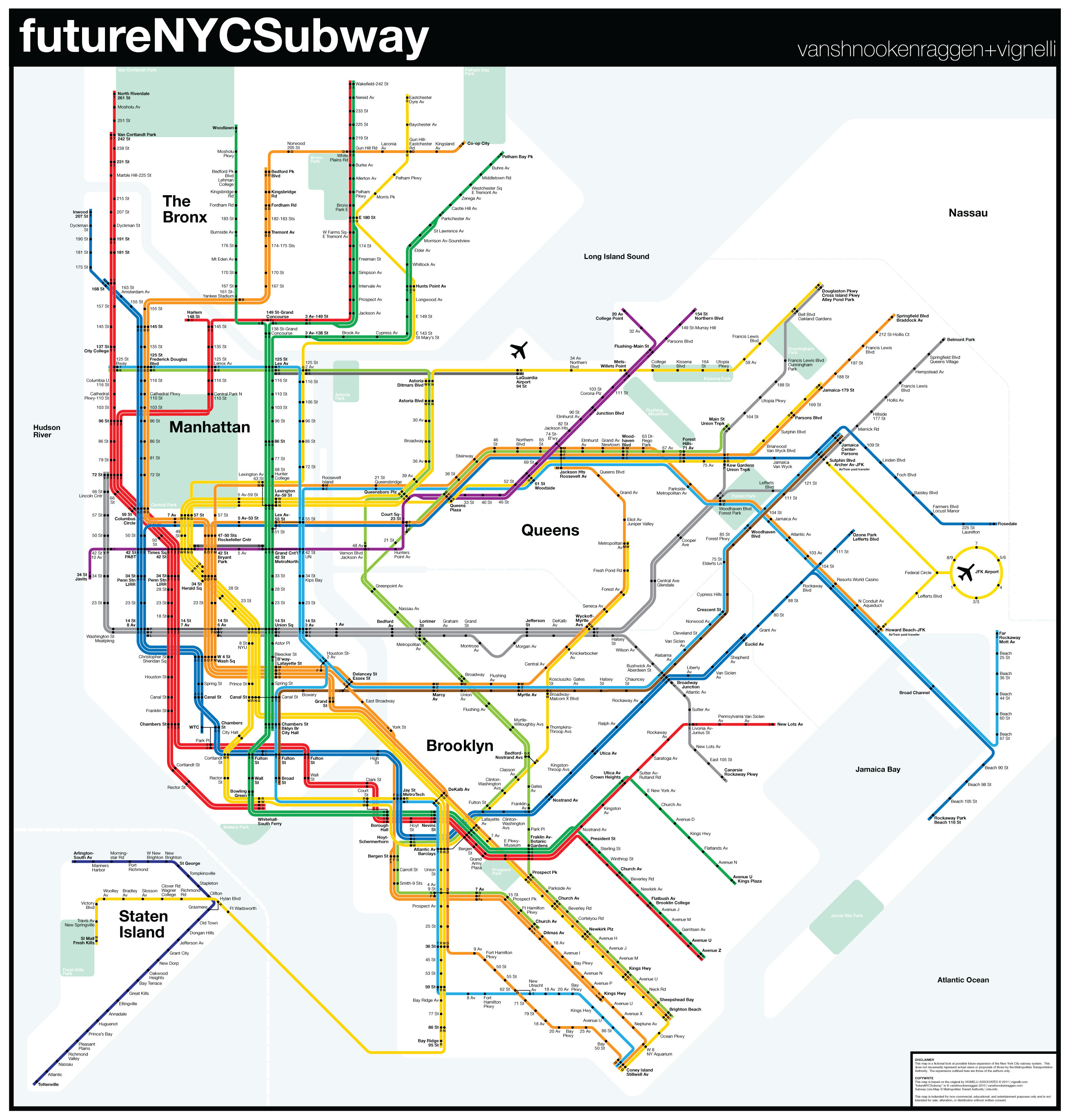
New York remains the world’s premier global city, followed closely by London, and Asian hubs continue to rise. But in London, a 73-mile railway line, Crossrail, nears completion, while New York is nearing completion of only a few additional miles of subway, the first phase of the Second Avenue Subway. (And due to money and politics, this subway route only has two tracks, so express service won’t be an option once the route is finished. And how are they going to repair it with 24/7 service if service cannot be rerouted onto express tracks? With more delays.)
Author @ Second Avenue SubwayAuthor @ East Side AccessAuthor @ South Ferry Terminal
East Side Access, will bring Long Island Rail Road (LIRR) commuters into Grand Central Terminal, creating a terminal on Manhattan’s East Side to complement Penn Station on the West Side.
The Second Avenue Subway will relieve pressure on the overcrowded Lexington Avenue line and improve access to Lower Manhattan. The full length will run from 125th Street and Second Avenue to Hanover Square in Lower Manhattan. Phase I, which will construct the 96th, 86th, and 72nd Street Stations and tie into the existing system at a new station at 63rd Street, is now underway.
Extension of subway service to the far West Side will provide a link to the Javits Convention Center at 34th Street and 11th Avenue and support the transformation of the surrounding manufacturing and industrial neighborhood into a mixed-use community.
The Fulton Transit Center will improve access and passenger flow throughout an existing complex that connects subway lines. The design includes an underground concourse that will connect the Transit Center to the World Trade Center site and the subway lines there, as well as the PATH train to New Jersey.
The new South Ferry Terminal, now complete, replaced the existing single-track loop with a two-track station, greatly improving passenger flow at this critical intermodal point that connects the subway to the Staten Island Ferry and numerous express and local buses as well as the Whitehall Street subway station. The improvement supports better access to Lower Manhattan destinations, including the World Trade Center site and historic Battery Park.
7 Line at Hudson Yards (Riel, 2015)
.
But Asian cities are building modern subways from scratch, and/or expanding rapidly. Established global cities, such as Tokyo, Seoul, Hong Kong, and Singapore continue to expand their subways, while Beijing, Shanghai, and many other Chinese cities continue to build rapidly. Global cities compete with New York for trade and investment on a global scale. Where will a bank build its next office tower, creating thousands of local jobs and opportunities? Where will a school build its next campus, fostering innovation and fueling a creative economy? Where are the young and educated moving? New York must balance these global considerations with local concerns. How can the city alleviate affordability concerns while also improving its infrastructure and livability?
MTR T.O.D. in Hong Kong (Riel, 2015)
.
If given unlimited resources, of course, the MTA should expand the system. The L Line and the 7 Line should connect on the West Side and form a loop. The L’s B Division platforms should be widened in order to fit A Division trains, and the L could become an A Division line. The L already has CBTC, and the 7 is getting it soon. And yes, there are a myriad of additional extension proposals, but let’s stick with prioritizing the Second Avenue Subway for now…
Yet unlike Chinese subways, which have all been built within the past few decades, with current technology, the MTA is dealing with an extremely old system, whose maintenance was deferred for decades in the 70s and 80s. Thus, the MTA must continue to spend most of its limited resources bringing its infrastructure into the 21st century. Or, since a lot of it is failing or falling apart, at least bringing it back into the 20th century. We all know too many stations that desperately need attention. Paint chips off ceilings, goo drips from wall tiles, sludge sits on track beds, and garbage stains platforms. Ironically, the subway was originally created in order to alleviate health concerns resulting from congestion in Manhattan, but now, poor station conditions can also create cleanliness and public-health concerns.
Chambers Street (Riel, 2014)Chambers Street (Riel, 2014)Chambers Street (Riel, 2014)
.
Thankfully, the MTA has been fixing up stations. For instance, only a tiny swath of chipped ceiling remains at West 4th Street. The harder challenge is maintaining those improvements consistently across a system of hundreds of stations.
West 4th Street (Riel, 2015)West 4th Street (Riel, 2015)West 4th Street (Riel, 2015)
.
But on the streets, too, the Department of Transportation needs to continue to repair and maintain our infrastructure, most of which was built from 1890 to 1930. Gridlock Sam has already warned us that we’re entering a period of rapid failures throughout the city, as most of our infrastructure is quite old. Concrete falling from a bridge? Water main burst? According to Sam Schwartz via Crain’s New York Business:
What’s on the transportation horizon for New York this year?
My concern is there will be a major infrastructure failure sometime in 2016 or 2017.
A bridge collapse?
More likely a concrete failure, which will result in engineers shutting it down. The concrete will either rain down on the traffic below or punch a hole through the deck. That hole could be as big as a car. Or it’ll be a major water-main burst. We may see Fifth Avenue underwater with the sun shining.
Why now?
Our infrastructure is reaching the end of its useful life. The big period of building in New York City was 1890 to 1930. It was such a rapid period of building that now there’s going to be a rapid period of failure.
Are there any particularly problematic spots?
Most worrisome to me is the BQE system in Brooklyn Heights, the triple cantilever. That needs to be addressed immediately.
Probably the Kosciuszko Bridge—that’s also a structure that has the potential for some failures. [Construction of a replacement is underway.]
Your Move New York Fair Plan would toll the East River bridges and raise money for infrastructure projects. What are its prospects?
We are waiting for the “three men in the room.” The governor hasn’t killed it, which we take as a pretty good sign.
What about subways?
Sadly, we’re going to see pretty much the same subway system we had. At the end of 2016, I predict that Governor Cuomo will get on a Second Avenue subway and ride it from 96th Street to Times Square. It will open to the public sometime in 2017. [North Brooklyn] riders are going to still stuff into the L train, or watch three or four trains go by until there’s room. We won’t see anything like [London’s universal fare card] until 2019.
You drove a cab while in college. What do you think will happen with Uber and taxis?
The mayor’s going to come out with a report; Uber is going to instantly challenge it. The mayor may try to introduce some legislation. He’s going to find himself weakened by his City Council—Uber has bought up just about every major lobbyist. So to see a cap [on car services’ growth] is unlikely. If the mayor decides to go a pricing way, Uber has already said to me that they would support a pricing formula that was fair as long as it was applied to everybody the same way.
Is the number of for-hire vehicles going to keep expanding?
What we had in the 1910s and 1920s, the car came up—gee, what a good business! And we had a depression. So everybody just took his own car and made it into a taxi. And if you go to Moscow now, everybody does that, and that’s why Moscow doesn’t move. So if you carry Uber to infinity, you have paralysis. This was so disruptive. We’ve never seen anything this dramatic, but there’s something that’s coming that’s much bigger than this. And that’s the self-driving cars. The Uber driver has a life of about 15 years, and then it’s going to be autonomous vehicles anywhere, any time you want them.
Also on the streets: I cannot think of another American city where residents consider heaps of trash along sidewalks to be acceptable. Yes, Manhattan was not designed to have alleys because the elite and influential New Yorkers at the time charged in establishing a comprehensive street plan for Manhattan viewed alleyways as dangerous to the health and well-being of the city. But because DOS does not pick up commercial trash, these businesses contract private companies to haul their garbage, and often, these irregular schedules create havoc on the streets. Trash piles and rats arrive.
And while these are public health issues that New Yorkers can see (and smell) easily, they are only the tip of the iceberg. For instance, subway passengers are rightly frustrated by delays, or by a lack of cell service. But in order to tackle the root causes of delays, signal systems would need to be updated, so that increased ridership can be met by more frequent service. In order to fix signal systems, work on the right-of-way would need to be conducted, causing more delays and service changes. And since the subway operates 24/7, delays are going to be common as track, line equipment, and line structures are renewed and enhanced. People also forget about electrical substations, pumps, and tunnel lighting. And what about delays from actual train problems, or adding countdown clocks in stations? Well, in order to maintain trains, the subway’s shops and yards need to be maintained. And in order to install countdown clocks in the B Division, the signal system would need to be updated, so NYCT knows exactly where trains are located; in fact, they spent billions in order to update signals for the A Division so that countdown clocks could be installed. Unfortunately, the MTA does not do a good job explaining why they have these problems. Perhaps passengers would be more understanding of delays if the authority had a better narrative. Yet they have a hard enough time even announcing that there’ll be delays…
NYCT 20th Century Signaling Infrastructure (Riel, 2015)Courtesy of MTA
.
But we mustn’t lose hope for a brighter future for our city. We must dream big and build big. We must reform our zoning and land use in order to streamline development, and make it easier for housing to be constructed, thereby increasing the supply and quenching the demand, so as to alleviate cost. We must encourage public-private partnerships. Land along subway corridors should continue to be up-zoned, and developers should be allowed to build taller if they build affordable units and contribute towards the renovation of nearby subway stations. Where appropriate, public transportation agencies and the City should coordinate land-use approvals to make productive use of development opportunities above yards, depots, and other transportation facilities while preserving their operational needs. These are already cost-prohibitive sites, due to their location, their size, and the costs of decking (and ventilating) over active sites with complex machinery operating 24/7. Zoning does not need to add to the mess. The city needs to be even more dynamic and dense, while also being livable.
The MTA provides for a sustainable commute, reducing GHG emissions, and more MTA ridership increases farebox revenue, allowing them to, perhaps, one day, become self-sufficient. And more MTA real estate revenue, however marginal, cannot hurt. The same can be said for Port Authority assets and air rights, and, essentially, all public assets. Could developers build atop schools and libraries, and contribute funds towards renovating these New Deal (or earlier) buildings? This is the type of creative financing that New York needs. Enough of the siloization! We need choice!
P3 Station Entrance (Riel, 2014)P3 Station Entrance (Riel, 2015)
.
New York’s physical infrastructure — from the Brooklyn Bridge to the IRT, BMT, and IND — allowed it to come together and become, arguably, the capital of the world. The powers, identities, and ideologies behind the creation of these networks believed in regionalism and understood that transportation allowed for people to access jobs and opportunities. But its people are the true reasons why it has succeeded for centuries. New York is fueled by its diversity and multiculturalism, and its people must be protected from displacement. While neighborhoods are always changing, a balance must be found between change and preservation, and between place and people. Urban planning can help to create meaningful communities and (re)New York City.
NYC DOT Brooklyn Bridge (Riel, 2014)Port Authority George Washington Bridge & Air Rights Buildings (Courtesy of APA)Lincoln Tunnel Helix (Riel, 2015)
.
Because major Port Authority and MTA expansion projects are expensive and slow to deliver, the region also needs lower-cost and incremental strategies. Informal transportation, joint development, and better use of existing public property all deserve consideration. The city needs to encourage choice, by regulating informal transportation opportunities, rather than banning them. When it comes to choice, the city, too, needs to foster school choice, and allow schools to build housing atop their structures in order to fuel Department of Education revenue. Transportation hubs, too, need to be built taller. There is no excuse for a four story Fulton Center in Lower Manhattan. The MTA may not have a profit motive or real estate expertise, but if they are going to be spending billions renovating and relocating to a new HQ only a few blocks away along Broadway, then they might’ve simply built a HQ atop their own eminent domain property.
Informal Transit Map (Source: http://goo.gl/kte5ZW)School on MTA Property (Riel, 2014)Hudson Terminal T.O.D. of Hudson & Manhattan RR (Predecessor to WTC and PATH)
.
The most important transportation project of the century may be a transportation policy: congestion pricing, which is already commonplace in many European cities. But we cannot simply ‘transport transportation‘ here, as our own context must frame the discussion. NYCDOT bridges are not tolled because they are directly controlled by the City, which, over one hundred years ago, removed tolls on the East River bridges. But as public authorities, the MTA’s and Port Authority’s bridges and tunnels, some of the longest and busiest in the world, are tolled, supplying revenue to their respective public transit operations. Tolling our free bridges will reduce congestion, alleviate public health concerns, and positively impact the Mayor’s Vision Zero transportation safety policies. Funds will be used to maintain roadways, commuter rails, and subways. And better subway service helps drivers, too, by keeping more vehicles off of the roads throughout the region of 20+ million people.
The MTA network spans 5,000 miles, with more than 2,000 miles of track—enough to stretch from New York to Phoenix, Arizona. They use enough power to light the city of Buffalo, and their bridges have enough support cabling to circle the Earth more than 3.5 times. One in three public transit riders in the U.S. are on the MTA network. Put together, these assets are worth nearly $1 trillion and require ongoing investment to keep them safe and reliable. Thus, the MTA is working on exciting projects, as detailed in their 2015-2019 Capital Plan:
Continue the progress we’ve made on two of the largest transportation projects in the nation: the next phase of the Second Avenue Subway and East Side Access, which will bring the LIRR into Grand Central Terminal. Both of these projects will add capacity to our system, and improve the reliability of our service by giving customers new ways to get where they’re going—to, from, and within New York City.
Complete the Long Island Rail Road Double Track project, which will allow us to add off-peak service in both directions for intra-Island commuting.
Replace our 1930s-era subway signals with Communications-Based Train Control, increasing capacity and reliability while improving safety.
Introduce a host of service improvements, including a new fare payment system, mobile onboard ticketing, and more real-time service information with new apps to match.
Continue to modernize our system with new trains, buses, and Help Points.
Review Transportation Reinvention Commission recommendations, so Capital Program investments maximize economic growth and better address the challenges of climate change and regional population growth.
… And all of the Port Authority’s visions, as well as the City’s. But these agencies and authorities need to cooperate and interconnect! Imagine through-running from New Jersey to the US Open or JFK, or from Long Island to EWR. Indeed, Penn Station (and/or Moynihan Station) should be a station, and not a terminal. Currently, the region’s commuter rails require separate ticketing, and at Penn Station, NJT, LIRR, and Amtrak are clogged by politics. Unlike the Center City Commuter Connection in Philadelphia, and unlike the RER in Paris or S-Bahn in Berlin or Crossrail (& Overground) in London, our commuter railroads are stymied by separate agencies and state boundaries. Penn Station was designed for through-running, but currently, conductors need to check their trains to make sure no one’s there before heading to rail yards; Amtrak needs to clean their cars and restock their cafe cars. According to ReThinkNYC, “these capacity limits prevent riders on certain NJ Transit lines from taking single-seat rides into Manhattan (tunnel capacity is another constraint), and this also means that Metro-North is unable to offer service to Penn Station from New Haven”…
And, what about updating the PA Bus Terminal? Or light rail along crosstown routes? Or more public spaces, more ferries, more bike lane enforcement from NYPD? Getting the new Hudson Tubes built? Expanding BRT (Select Bus Service) and coordinating with DOT in order to keep buses moving faster (i.e., transit signal priority), whilst working with NYPD to enforce bus lanes? Courtesy of NYC.gov:
Select Bus Service Features
Select Bus Service can feature a number of different elements designed to improve bus speed and reliability, as well as enhance the customer experience. The New York City Department of Transportation, New York City Transit, and MTA Bus study each Select Bus Service corridor in depth, and seek substantial community feedback, in order to design the right set of improvements for each corridor. These can include:
Enhanced road markings will increase the visibility of bus lanes. Many bus lanes are colored with dark red terra cotta paint, and all bus lanes include white BUS ONLY markings. The red treatment has been shown to help make sure motorists are aware of the bus lane, and do not drive or park in the lane during restricted hours.
Curbside bus lanes are travel lanes for buses at the curb. Curbside bus lanes are only in effect during certain times of the day and can be used by regular traffic during other times. For hours of operation, check the on-street curb regulation sign.
Off-set bus lanes are travel lanes for buses one lane away from the curb. These lanes serve buses as well as right-turning traffic and emergency vehicles. The lane next to the curb may be used for parking, loading, or kept entirely clear.
Bus lane cameras are used to enforce bus lane rules on selected streets around the city; cameras may only be used on specific corridors authorized by the New York State Legislature. All potential camera violations are reviewed by a DOT employee before being issued, to ensure that a violation took place. On all corridors, DOT works closely with the New York Police Department to enforce bus lane rules. All bus lane violations are adjudicated by the Department of Finance, not by DOT.
Off-board fare collection means that bus riders pay with a MetroCard or coins at a sidewalk ticket vending machine at the Select Bus Service bus stop before they get on the bus. Riders may then board the bus through any door, without needing to show the ticket to the bus operator. This shortens the time the bus is stopped at the station substantially, compared to the traditional method of entering one at a time through the front door. NYCT employs fare inspectors who may randomly inspect tickets to ensure compliance; passengers without a ticket are subject to a $100 fare evasion summons.
Bus bulb stations are locations where sidewalks have been widened to meet an offset bus lane or general travel lane. Bus bulbs provide more room for people to wait, provide more room for amenities like bus shelters, benches, and greenery, and they allow buses to travel straight into and out of the station without pulling over. These stations also have a high curb wherever possible that will be near-level with the floor of the Select Bus Service buses, making it easier and faster for all passengers to get on and off the bus.
Transit signal priority, uses GPS to track when a bus nears an intersection, and turns traffic signals green sooner, or keeps them green longer, allowing the bus to keep moving through the intersection and shortening the overall time of the bus trip. Implementing transit signal priority also includes coordinating the traffic signals on the corridor for all vehicles, which improves travel times for both buses and other traffic on the street.
Minimum bus stop spacing allows buses to travel faster by not having to stop very frequently. Select Bus Service routes have a simple route pattern with stops farther apart than typical bus routes, such as at major destinations or transfer points. Local buses will typically continue to serve all stops.
Real time arrival information provides riders with how far away the next arriving bus is, as provided by the MTA Bus Time system. Real-time information can be viewed on real-time signs located at bus shelters and is available by cell phone or over the internet.
Upgraded signage on all routes will establish when the bus lanes are in effect. At a minimum, this will include at least one sign per block, positioned for high visibility for motorists. Additionally, large overhead signs will be located along the corridor to ensure that the rules of the road are clear.
Pedestrian and driver safety is an important aspect of SBS design. Features such as neck-downs and pedestrian islands are used to shorten crosswalks and increase safety for pedestrians while enhanced street organization improves safety for drivers, bikers, and pedestrians alike.
New bus shelters are installed by Cemusa, the city’s bus shelter franchisee. Bus shelters are installed at all Select Bus Service stations where physically feasible, with double shelters used where possible.
Last month, US Vice President Joe Biden joined Gov. Andrew Cuomo of New York to unveil a much needed $4 billion renovation to New York’s “third world”LaGuardia Airport.
Criticism of the plan to revitalize New York’s smallest and most despised airport came quickly. Most notably, there were complaints about a lack of adequate transportation to the terminals and decreased parking on-site.
While politicians patted themselves on the back in front of the decaying terminal, thousands of commuters faced repeated delays into and out of Penn Station, the busiest rail hub in North America, because of issues with aging infrastructure in the century-old tunnels beneath the Hudson River.
A group called ReThink NYC has a plan to alleviate both these issues, ease Penn Station overcrowding, raise the airport above the flood plane it now inhabits and extend the runways to standard length.
The hallmark of the group’s proposal is an intermodal rail hub, with connections to Amtrak and Metro-North, as well as a hotel and convention center, in the Bronx just across the bay from LaGuardia.
The lead designer of the group, Jim Venturi, told Business Insider that inspiration for the lofty plans came from the recently opened Fulton Center, a retail and transit complex near the World Trade Center, which overran projected time and costs to the tune of seven years and $650 million.
“I thought, ‘I have other ways to spend $1.4 billion,’” Venturi said. “And eventually I thought to myself, ‘Well instead of criticizing someone else’s things why don’t I come up with my own ideas?’”
ReThink NYC’s plan solves more than just LaGuardia’s woes. It would also increase capacity at the clogged Penn Station, open space in the Sunnyside Yard, where trains from Penn Station bide their time between commuter runs, and allow easier access to the airport from the Northern Suburbs.
“If you look at what Biden said last year, and you compare that with the scheme that was proposed, it doesn’t meet the goals that Biden set out,” Venturi said. “It is an evolutionary change, not a revolutionary one, and Biden specifically counseled against that.”
It’s a big bet, and it certainly won’t be cheap or easy, but big projects are what’s missing in the new New York, Venturi believes.
“LaGuardia, with its proximity to the Northeast Corridor, has the opportunity to become the greatest rail connected airport in the world,” he said. “And it’s not hard to do it.”
“I disagree with the type of thinking that we’ve had after Moses, where changes have to be small, and people’s first reaction when you bring up an idea is ‘It’ll never happen,’ ” he said. “That’s what stops you.”
He added: “It’s 50 years after Robert Moses left power. And yet we still live in a Moses reality. We haven’t updated it. I think Moses wouldn’t want to live in a Moses reality today.”
Queens needs a real downtown, accessible by commuter rail. Midtown Manhattan is right across the East River from Sunnyside, but Sunnyside is no commercial hub, partly because it is not a transit hub. Yet subways already stop there, and so, too, could Metro-North, Long Island Rail Road, New Jersey Transit, and Amtrak. This hub would be one stop away from LaGuardia, which would be extended, expanded, and raised (to prevent flooding) towards Randall’s Island. Currently, runways are too short for larger airplanes, and they also cause weather delays, which impact the entire domestic flight network, and force planes to circle around the skies, emitting GHG, awaiting arrival. With LGA connected to the Northeast Corridor, only a few minutes from Midtown Manhattan, New York will be ready for the 21st century.
And, what about connecting the PATH with NYCT? Bringing the PATH at WTC into the 6 Line? Or the PATH at 33rd into the IND 6th Avenue, if it fits? Alternatively, bringing the 7 to Secaucus? I know that PATH goes to New Jersey and the MTA is a New York public authority, but perhaps Governor Christie would be fine allowing the MTA to operate PATH? Plus, surely the self-sufficient Port Authority would also be fine if it no longer had to deal with PATH, as it is a big financial drain on the authority, propped up by bridge and tunnel tolls, as well as airport and port fees. And, New Jersey could still help to pay for it, just as the MTA currently pays New Jersey Transit to operate the Metro-North Port Jervis branch, and just as Connecticut DOT (ConnDOT) shares the costs associated with Metro-North’s New Haven Line in Connecticut. So, there is precedent in the region for more inter-state, inter-agency collaboration! Moreover, with PATH under MTA control, as simply an additional two or three subway lines, there will be free transfers, and it will be interconnected with the rest of the subway, fueling growth in Hudson County and Newark.
Source: http://www.thetransportpolitic.comWhat if the PA, NJT, and MTA were actually integrated? Courtesy of MTA.infoTrans-Hudson Railroad (Prior to Bankruptcy & PATH)
.
There’s a lot to do in order to renew, enhance, and expand our city and region for the 21st century. Will money and politics get in the way? Or will a champion be able to frame a fair and balanced narrative, and bring us together, so that we can be proud of our infrastructure, and so that we can continue to attract the best and brightest? Because New York needs new, creative leadership, which understands the interdisciplinary and interconnected importance of transportation infrastructure.




Leave a Reply