NYC’s “Sixth Borough” — NYC Harbor (Riel, 2015)NYC’s “Sixth Borough” — Hudson River and Downtown (Riel, 2015)NYC’s “Sixth Borough” — Hudson River and Uptown (Riel, 2015)NYC’s “Sixth Borough” — East River Bridges (Riel, 2015)Brooklyn Bridge (Riel, 2015)Brooklyn Bridge (Riel, 2015)Statue of Liberty (Riel, 2015)Rockaways (Riel, 2015)Rockaways (Riel, 2015)Sea Gate: Brooklyn’s Gated Community (Riel, 2015)Coney Island (Riel, 2015)Western Queens and East River (Riel, 2015)
New York City, arguably the world’s premier global city, is the largest in the richest country in the world. The metropolitan region hosts 23+ million people, more than the population of Australia, and New York’s population continues to rise. The MTA network spans 5,000 miles, with more than 2,000 miles of track—enough to stretch from New York to Phoenix, Arizona. One in three public transit riders in the U.S. are on the MTA network. And just one line, the IRT Lexington Avenue Line, has more ridership than San Francisco, Chicago, and Boston’s entire systems, combined.
So, what is the state of the city? Seems as though the State has announced plenty for the City, fueling the feud between Mayor Bill de Blasio and Governor Andrew Cuomo. Indeed, after recently reaching an agreement with the City of New York to fund the MTA Capital Plan, Governor Cuomo has proposed a series of exciting projects to renew, enhance, and expand our region’s transportation infrastructure. While nowhere near the $305B allocated for America’s highways for the next five years, Governor Cuomo is proposing quite a lot of projects.
Gov. Andrew M. Cuomo of New York has been busily announcing big projects that would put him in a league with the master builder Robert Moses — if he can figure out how to finance them. That’s a big “if,” since the price tags run into tens of billions of dollars and the governor hasn’t been too forthcoming on where he thinks all that money will come from.
ESTIMATED PRICE TAG: $20 BILLION
Tunneling to New Jersey
Governor Cuomo and Gov. Chris Christie of New Jersey said their states would pick up half the cost of a badly needed new rail tunnel under the Hudson River, which could reach $20 billion.
ESTIMATED PRICE TAG: $1 BILLION
Javits Center’s Growth Spurt
Mr. Cuomo said Thursday that the Javits Center, a convention and exhibition hall on the Far West Side of Manhattan, could be expanded by 1.2 million square feet under a $1 billion project “paid for by the Javits Center within existing resources.”
ESTIMATED PRICE TAG OF THE COMPLEX: $3 BILLION
Pennsylvania Station, Version 3.0
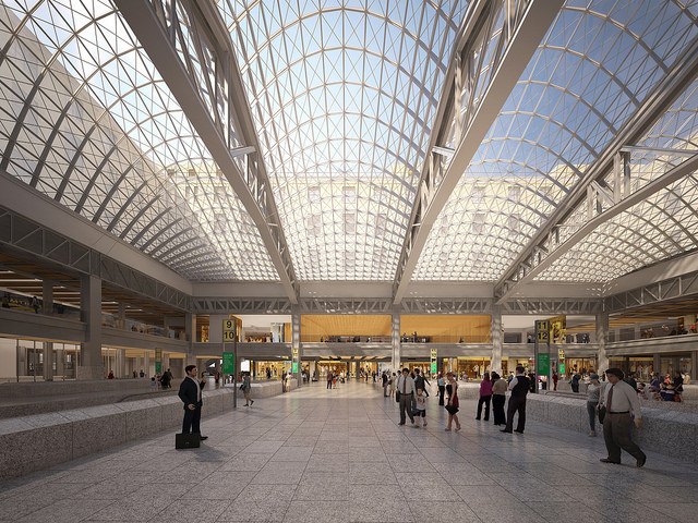
Under Mr. Cuomo’s plan for an “Empire Station Complex,” the third Pennsylvania Station in 105 years would be created on the site of the current claustrophobic waiting room. A new Long Island Rail Road concourse would run along 33rd Street.
ESTIMATED PRICE TAG OF THE COMPLEX: $3 BILLION
From Post Office to Waiting Room
Also as part of the “Empire Station,” the central court of the James A. Farley Building, New York’s general post office, would be turned into a railroad waiting room and shopping center. Planners have dreamed of this for 23 years.
ESTIMATED PRICE TAG: $4 BILLION
A New La Guardia Airport
Mr. Cuomo promised last summer that the decrepit and unloved La Guardia Airport would be replaced “in its entirety” by 2021. The $4 billion estimate sounds low, since this was the cost of the World Trade Center Transportation Hub alone.
TOTAL FIVE-YEAR M.T.A. PLAN: $29 BILLION
Among Billions, Money for Utica Avenue
The $29 billion, five-year infrastructure plan for the Metropolitan Transportation Authority to which Mr. Cuomo and Mayor Bill de Blasio agreed last year includes $5 million to pay for a study exploring a Utica Avenue subway extension in Brooklyn.
ESTIMATED PRICE TAG: $1 BILLION
A Third Track for the L.I.R.R.
In Nassau County on Tuesday, the governor said he would push a plan to add a third track on the Main Line of the Long Island Rail Road, between Floral Park and Hicksville. He offered few financing details.
ESTIMATED PRICE TAG: $3.9 BILLION
Bridging the Tappan Zee Anew
A new Tappan Zee Bridge, linking Westchester and Rockland Counties over the Hudson River, is under construction. But it is not entirely clear how its $3.9 billion cost will be fully financed.
ESTIMATED PRICE TAG: $1 BILLION
Four Stops in the Bronx
The addition of four new Metro-North Railroad stations in the Bronx — at Co-op City, Morris Park, Parkchester and Hunts Point — has been on the governor’s agenda for two years.
While some have criticized this list, stating that it is about entering and leaving the Big Apple, and not improving the system within the city, Governor Cuomo has also announced Wi-Fi and cell phone service at numerous additional stations, and, alongside improved signal technology, subway station countdown clocks on the B Division. Overhauled stations, new subway cars, new buses, and bridge and tunnel repairs will also be part of the $29 billion Capital Plan.
So, how will Governor Cuomo pay for all of this? Sure, our economy is strong, but is he serious? The MTA doesn’t have funding for the next phase of the Second Avenue Subway, and cannot seem to maintain existing stations. Garbage piles on the tracks. Paint chips from the ceilings. Goo leaks from the walls. Gum blackens on the platform. Existing infrastructure remains vulnerable to climate-related threats. Flooding. Ice. Snow. And it took years upon years to figure out how to finance the Hudson Tubes. Now all of these projects?
Include NJT Newark Light Rail on Regional MTA Map? (Riel, 2014)Include NJT Light Rail in Jersey City on Subway Map? (Riel, 2014)
.
Finally, what about connecting the PATH with NYCT? Bringing the PATH at WTC into the 1 or 6 Line? Or extend it to the 7 at 42nd? (It was built to IRT specifications, so it could only fit within A Division tunnels). After all, it is a rapid transit network, operating 24/7, and it already accepts MetroCard.
I know that PATH goes to New Jersey and the MTA is a New York public authority, but perhaps Governor Christie would be fine allowing the MTA to operate PATH? Plus, surely the self-sufficient Port Authority would also be fine if it no longer had to deal with PATH, as it is a big financial drain on the authority, propped up by bridge and tunnel tolls, as well as airport and port fees. And, New Jersey could still help to pay for it, just as the MTA currently pays New Jersey Transit to operate the Metro-North Port Jervis branch, and just as Connecticut DOT (ConnDOT) shares the costs associated with Metro-North’s New Haven Line in Connecticut. So, there is precedent in the region for more inter-state, inter-agency collaboration! Moreover, with PATH under MTA control, as simply an additional two or three subway lines, there will be free transfers, and it will be interconnected with the rest of the subway, fueling growth in Hudson County and Newark.
New York City Subway, operated by the Metropolitan Transportation Authority (MTA), is the seventh busiest rapid transit rail system in the world, and the busiest in the US, with over 1.7 billion riders in 2012. Including the Staten Island Railway, the system provides service 24 hours a day, every day, in all five boroughs of New York City.
Port Authority Trans-Hudson (PATH), operated by the Port Authority of New York and New Jersey (PANYNJ), connects the New York City borough of Manhattan with the northern New Jersey municipalities of Harrison, Hoboken, Jersey City, and Newark, and carried 72.6 million riders in 2012, more than the entire public transit systems in Atlanta, Los Angeles, or Miami.
The Subway Map Today
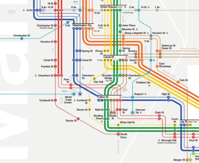
The current New York City Subway Map shows the PATH tracks and stations in Manhattan, but there are several deficiencies with the current display.
PATH is Incorrectly Represented– PATH is a rapid-transit system. It operates 24/7, provides frequent service with short headways (time between trains), accepts the same pay-per-ride MetroCard as the Subway for fare payment, and has six underground stations in Manhattan (four with direct physical connections to the New York City Subway). The current fleet of PATH train cars (PA5) are an updated version of the Subway cars (R142A) used on the 4 and 6 trains. However, PATH is represented on the Subway Map using the visual style labeled “Commuter rail service” in the map’s key: pale blue “railroad track” lines, square station markers, and small, lightweight text labels. This appears to be an incorrect application of the MTA visual style guide, and doesn’t effectively communicate to Subway riders that PATH is also a rapid-transit service.
Hudson Waterfront is Missing– PATH connects New York and New Jersey, but the Hudson Waterfront and stations across the river from Manhattan are missing from the current Subway Map, so Subway riders who want to connect to PATH to reach destinations in New Jersey currently see no information about where PATH can take them.
Proposed: A More Complete Map, Displayed on Both Systems
1. Display PATH as a Rapid Transit Service
Show PATH lines using a solid line rendered in the light blue color used for the PATH logo. Include PATH logo to identify the line. Replace current blue squares representing World Trade Center, Christopher St, 9th St, 14th St, 23rd St, and 33rd St stations with circles and labels that match the visual style of New York City Subway stations. PATH trains make all station stops, so black circles should be used to indicate local service. In Subway Map Key, add PATH logo and the following information: “Port Authority Trans-Hudson (PATH) service is operated by the Port Authority of NY & NJ. PATH accepts the Pay-Per-Ride MetroCard for fare payment; Unlimited Ride and EasyPayXpress MetroCards are not accepted on PATH: Visit panynj.gov/path for more information.”
2. Include Hudson Waterfront and Stations
There is room within the current boundaries of the Subway Map to include the Hudson Waterfront and four of the seven PATH stations in New Jersey. Add geographical representation of Hudson Waterfront to left edge of map, and include labels for Jersey City and Hoboken, waterfront cities with PATH stations. Add black circles and labels to represent stations at Exchange Place, Grove Street, Hoboken, and Newport. Add an arrow to indicate that service continues off map to Journal Square, Harrison, and Newark.
Of course, this makes complete sense. But our agencies are social, economic, political, and physical silos, and the gaps between them need to be bridged in order to connect the PATH with the MTA, and in order for through-running at Penn Station between New Jersey Transit, LIRR, and, perhaps, one day, Metro-North. And in order for so many more projects to commence, so we’re ready for the 21st century. However, regional planning is difficult in the United States, and it is important to recognize States’ rights. If it is difficult for PATH to be shown on the subway map, then it will definitely be difficult to actually connect it physically!
Ideally, the MTA should be completely reformed. It makes no sense for New Jersey to not be connected to our subway network. In an alternative universe, a 51st state, based upon our metropolitan region, would allow for regional planning. Let’s call it the Big Apple State, or New Netherland; after all, the area was, historically, controlled by the Dutch, before the British decided to divide the colonies of New York and New Jersey, respectively, along the Hudson River. (The British messed up borders all over the world).
For now, let’s get our heads out of the clouds and be practical. All of these plans are nice to envision, but we first need to fix our current system. We need to fix our signals, fix our tracks, and fix our fleet, so that we can have fewer delays due to malfunctions. We’d also have fewer delays because frequency would be increased, leading to less crowding on a system with continually increasing ridership. (Less crowding, of course, means less time spent in stations, with passengers holding doors and dealing with platform congestion).
Governor Andrew Cuomo has spent the week running from press conference to press conference, trash-talking New York City’s railways, airports and transit hubs even as he promises to make themgrander, glassier, and, he hopes, more efficient.
On Friday morning, the MTA was the focus of the Governor’s poetic waxing. From a podium at the MTA Transit Museum in Downtown Brooklyn, he promised a bevy of technology updates to be rolled out over the next five years, some more cosmetic than others.
For one, Cuomo is pushing for an expedited rollout of countdown clocks for lettered trains and the 7 line, starting this year. Granted, the MTA promised eventual letter train countdown clocks back in 2009. But last March, MTA spokeswoman Amanda Kwan told us that the MTA doesn’t have “a specific timeline for the lettered lines.”
.
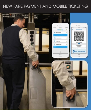
Cuomo also announced a new digital ticketing system that will allow straphangers to buy their MetroCards online by 2018, and the LIRR and Metro North have pledged to introduce mobile ticketing in the next six months. This technology will extend to subways and buses in 2018, allowing riders to enter the subway by waving their cellphones in the direction of a contactless detector.
The MTA confirmed its intention to phase out the MetroCard completely.
Insisting that his goal is to build a New York for the “next hundred years,” Cuomo added, “The MTA is the heart of it. Because you know what the future is? The future is mass transportation.”
Cuomo also promised system-wide Wi-Fi by the end of the year, and cellphone service in 2017, plus USB charging stations in 200 subway cars this year and 400 more next year. All new buses added to the system this year will have Wi-Fi. The number of buses with Wi-Fi and charging ports should clock in over 1,000 by 2018.
“I don’t want to get on a train and feel like a sardine for an hour and a half on the way to work. I don’t want to do that,” Cuomo extrapolated. “I want to be able to sit in a seat, I want to be able to listen to my music, I want to be able to make a telephone call, be connected to Wi-Fi. I’ve come to expect that.”
This, from the guy who, apparently, has never taken a city bus. The same governor also declined multiple requests from advocates to take a peak-rush-hour subway ride, and instead made an underground appearance in cardboard form.
And then there’s this. MTA Chairman Thomas Prendergast took to the podium Friday as well, promising to “re-envision” 30 subway stations by 2020. The MTA plans to make these stations “cleaner, brighter… easier to navigate, with better and more intuitive wayfinding, as well as a modernized look and feel.” This means more On The Go touch screens, new signage, new lighting.
Rather than close these stations on nights and weekends to accomplish this “renewal”—the Governor described the current approach as “piecemeal”—the MTA will shut down entire stations for an average six to twelve-months per station to expedite renovations. Will your neighborhood’s subway station be one of them? Read it and weep/breathe a sigh of relief.
An MTA spokesperson said the full shut-down plan may be modified at stations without an obvious alternative transit option nearby.
After Cuomo’s announcement, some critics argued that the MTA is facing more pressing issues than, say, “customer-friendly” initiatives.
As for how this large-scale, high-tech makeover will be funded, MTA spokesman Adam Lisberg confirmed that the funding will be covered by the 2015-2019 Capital Program, which has yet to be formally approved.
“The MTA is committed to meeting Governor Cuomo’s challenge head-on, eliminating every possible inefficiency to deliver these improvements faster, better and at a lower cost,” MTA Chairman Thomas Prendergast said in a statement. He added that the authority will accomplish this in part through public-private partnerships.
“These are vital investments to modernize subways and buses and make the daily commute less awful for eight million New Yorkers,” said Rider’s Alliance director John Raskin. “But in order to make them happen, Governor Cuomo has to approve the MTA capital program so the MTA can begin doing the work, and he has to identify how he plans to pay for it all.”
Remember, our system already maintains more stations than any other system on the planet, and operates 24/7, while working on the right-of-way when most other systems are closed for their nighttime windows. We can do this, thankfully, because we have express and local tracks for re-routing. The ingenuity of engineers long gone continue to keep our wheels moving strong.
New York continues to attract the creative class, but needs to work on creative financing. Informal transit networks are creative, distinct, and vibrant, providing a self-sufficient backbone to neighborhoods without good transportation access. Existing licensing and operating rules can make legal operation difficult, even though these services provide important mobility in neighborhoods with limited transportation options. As it stands, the city has made it easier to get licensed as a van operator, and they continue to crack down on unlicensed drivers and unsafe driving. However, there’s a Catch 22: to be licensed is one thing, but to pick-up passengers is another thing entirely. Akin to non-medallion car services (a.k.a., non-yellow and non-green taxis), vans are not supposed to pick up street hails. They also are not supposed to stop at bus stops or compete with the MTA.
Imagine, as The Atlantic imagines, these services popping up throughout the city.
What’s interesting about dollar vans, if they’re properly licensed and insured — and reasonably legal — is that they could gravitate to where the riders are and where they want to go faster than public transit, which requires more infrastructure and meetings. In some cities, bus routes have histories going back decades, and they don’t change to reflect how people’s lives and work habits have changed. ([Buses] certainly don’t [wait for you to drop off your children] at daycare centers.) Dollar vans are out there to make a buck, and that’s not bad for passengers.
Why does the city keep them from flourishing? After all, according to the Wall Street Journal, they can be faster, and you get a seat every time. But part of the problem, according to me, is a lack of smart regulation. These drivers are incentivized to pick up as many passengers as possible and compete against other vans, so sometimes they’ll go fast, make illegal turns, or honk really loudly all the time. The city wants to keep passengers safe, and they also don’t want vans competing with the TLC’s taxis, which pay a lot for street hail medallions.
Vans on Flatbush Avenue in Brooklyn (Riel 2014)
.
But the benefits of these vans far outweigh the costs, so long as the city regulates these vans with smarter laws. How about GPS devices to make sure they aren’t speeding or making illegal turns? After all, these services combine the efficiency of private-sector enterprise with the safety of law enforcement. With people getting forced to live further and further away from subways, these services need to be catalyzed. Plus, if there’s better transportation access in the outer boroughs, perhaps there will also be more “back office” jobs located there.
We are definitely lucky that we have the MTA. But in cities without safe, government-subsidized subways and buses, informality takes over. Vans like those in the outer boroughs of NYC are omnipresent in many developing countries, where the battles and balancing acts between formality and informality are played out daily. Kenya’s matatus, recently being pressed to adapt Google’s electronic payment methods in order to combat corruption and increase efficiency, are one example of this phenomenon. In fact, my friend has been working tirelessly on this project for years now through his organization, Groupshot.
These are just some examples of how informality can bridge the gap – often literally, if the vans go on bridges or in tunnels. These vans are essentially Uber/Lyft services on “steroids”, helping to take more cars off of the road, and helping to free up more space for humans. Imagine a downtown with fewer parking lots, and more space for parks. Or, imagine transit-oriented infill development, catalyzed by a public-private partnership and informality-formality collaboration.
We have a city with rising rent, rising seas, and rising inequality. The peripheries of the metropolitan area are under-served by mass transit, and they also have plenty of opportunity sites for housing and for jobs. Atlantic Avenue in Brooklyn, for instance, is a major East-West corridor. The Mayor’s affordable housing plan has identified Eastern Brooklyn as a primary center for residential development, due to a relatively high amount of opportunity sites. This is partly due to arguably outdated zoning laws, which prohibit residential development on abandoned lots that are currently zoned for manufacturing, so the lots are remaining vacant until it becomes profitable to develop them (i.e., until the zoning changes). In my opinion, corridors akin to Atlantic Avenue, with subways nearby, should be a lot more dense. We cannot complain about high housing costs when we’re living in single-family homes above a subway station, and when there’s vacant land nearby.
We should not be limiting the freedoms of these drivers; we should be enabling them. Likewise, we should be unleashing developers. We must dream big and build big. We must reform our zoning and land use in order to streamline development, and make it easier for housing to be constructed, thereby increasing the supply and quenching the demand, so as to alleviate cost. We must encourage public-private partnerships. Land along subway corridors should continue to be up-zoned, and developers should be allowed to build taller if they build affordable units and contribute towards the renovation of nearby subway stations. Moreover, the MTA’s far-flung assets, such as its yards and depots, should be exempt from municipal zoning and land use laws, so as to incentivize developers to construct transit-oriented, transit-owned developments atop, wherever feasible. These are already cost-prohibitive sites, due to their location, their size, and the costs of decking (and ventilating) over active sites with complex machinery operating 24/7. Zoning does not need to add to the mess. The city needs to be even more dynamic and dense, while also being livable.
Where decking is technically and financially feasible, the City and MTA should coordinate zoning, financing, transportation operations, affordable housing, and public review so that transit-owned sites can support additional development without compromising their transportation function.
Thus, creative financing can bridge the gap, at least, marginally, in Cuomo’s projects. He understands that developers can finance much of a new Penn Station, for instance:
Governor Cuomo announced on Wednesday that he is spearheading a comprehensive overhaul of Penn Station. In conjunction with Amtrak and the MTA, the renovation will seek a private developer to convert the Farley post office building on Eighth Avenue into a grand, sun-soaked waiting area. The project—dubbed the Empire Station Complex—is estimated to cost more than $3 billion, with $2 billion going towards the Farley-Penn overhaul, and an additional $1 billion towards retail development along 7th and 9th Avenues.
About $325 million is expected to come from the government, split between the Department of Transportation, Port Authority, and Amtrak. The rest will be privately funded, in exchange for interest in the revenue generated long term by retail and commercial rent.
The Farley conversion, to be dubbed “Moynihan Train Hall” according to Politico, would be the realization of the significantly stalled Moynihan Station project. Acknowledging that such an overhaul has been a long time coming, Cuomo said that the project would be expedited, and completed within three years. The Farley renovation is slotted for completion first. According to the Governor’s office, the new hall at Farley will increase the size of Penn station by 50 percent, and will be comparable in size to the main room at Grand Central. An underground “link” will ultimately connect Farley to the existing Penn Station building under Eighth Avenue.
In one scenario, the Madison Square Garden Theater on Eight Avenue would be removed entirely, in what Cuomo described as a “friendly negotiated condemnation and removal.” The demolition would allow for a possible block-long entrance to Penn Station across from the post office building. This proposal is similar to one put forth by the Municipal Art Society in 2014, and would theoretically yield a new space with abundant space and natural light.
Another option would involve temporarily shutting down the 33rd Street block of the station, and constructing a massive, glassy new entrance with accompanying skylights. Developers could also leave the exterior of the station largely unaltered, “improving the configuration of the interior” with wider concourses, new signage, and integrated wifi, according to the Governor’s office.
The Farley overhaul and Penn renovation may be carried out by one private developer, two, or a small coalition. In the case of Farley, the developer will earn full retail rights inside the space. Cuomo announced that his office will be issuing solicitations to private developers this week, which will be due back in three months.
Citing anonymous sources close to the Governor, the Wall Street Journal reports that such a renovation could lead to the severing of a decade-old agreement between Penn Station and private developers Vornado and the Related Cos., who had initial plans to renovate the post office building into a station. However, the sources told WSJ that the cost of severing that agreement would be small “relative to the overall project.”
Municipal Art Society executive director Mary Rowe said, “We echo the Governor’s conviction that Penn Station is in need of urgent and ambitious change… finishing the Moynihan project and relocating the MSG theater is critical to improving Penn Station.” However, “In the long term, these improvements won’t be enough to fully address Penn Station’s severe overcrowding or meet the growing needs of its rapidly developing neighborhood and our regional economy.”
Mayor de Blasio did not attend the announcement, which is no surprise given the strained relationship between the governor and mayor. De Blasio spokesman Wiley Norvell stated this evening, “These are improvements the City has been pushing for over the past two years, and we’re glad to see the State stepping up with renewed commitments. It’s going to take the City, State and Federal governments working in close cooperation to make an expanded and revitalized Penn Station a reality. Together, we can deliver the 21st century transportation system New Yorkers deserve.”
I’m glad that Governor Cuomo is implementing value capture in order to, potentially, get this monster rebuilt. Ironically, developers paid for the original, decrepit Penn Station to be demolished and rebuilt underground, so that they use air rights and build Madison Square Garden and Penn Plaza. Now, they will be paying again. But this practice is carried out elsewhere in the city, the country, and the world. It needs to be streamlined, and public-private partnerships need to become more commonplace. Government needs to make it easier or get out of the way.
(And of course, value capture and joint development don’t have to only finance rapid transit. What about building atop schools, libraries, or highways, in order to finance these operations?)
7 Extension & Hudson Yards Value Capture (Riel, 2015)P3 Renovating Station Entrance in Brooklyn (Riel, 2014)Up-Zoning on Subway Corridors (Riel, 2014)Vacant Lot Along Subway Corridor! (Riel, 2014)Vacant Lot Along LIRR in Brooklyn! (Riel, 2014)Vacant Lot Along NJT in Newark! (Riel, 2014)
.
Unfortunately, joint development had a dark period in our city, when Penn Station was destroyed for Madison Square Garden. This was allowed by the 1961 Zoning Resolution, which divided the city into residential, commercial and manufacturing areas, and introduced incentive zoning and floor-area-ratio (FAR). The resolution also introduced Transfer of Development Rights (TDR), also known as air rights, in order to preserve green space and historical landmarks, without interfering with the financial rights of property owners. But Pennsylvania Railroad sold their Penn Station air rights, and was given a modern, subterranean station, which lost the light and the circulation. Today, the country’s busiest train station remains congested, and through-running no only occurs due to the balkanization of Penn Central into NJT and LIRR, both of which terminate in Midtown Manhattan. Going from Newark to JFK, or from the US Open to Secaucus? Good luck.
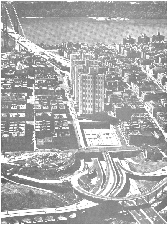
Air rights were also used atop highways. The Port Authority’s George Washington Bridge and Bus Terminal funneled vehicles along the Trans-Manhattan Expressway, below the Bridge Apartments. The 4,000 residents of these four aluminum-sheathed high-rises deal with noise and exhaust every day, but like most urban dwellers, they deal with it, and it’s better than leaving a gaping hole in Manhattan.
In principle, air rights go back to early English common law. To whomever the soil belongs, he also owns to the sky and to the depths. Though the air is now a public aviation highway, the practice remains utilized. But it should be easier to build atop assets. Since most railroad assets are in far-flung locations, land values are not as high as in a CBD. Yet zoning also limits potential. Transportation agencies should be exempt from municipal regulations. As a state authority, the MTA has a unique relationship with municipal regulations, but coordination with local governments remains important because transportation investments affect surrounding communities and the built environment.
The Zoning Resolution of the City of New York, as amended September 1962, defines railroad or transit air space as “space directly over a railroad or transit right-of-way or yard, which right-of-way [is] open, except for structures accommodating activities incidental to its use as a right-of-way or yard, and not otherwise covered over by any building or other structure at the effective date of this amendment.”9
The Resolution states that the City Planning Commission may permit developments or enlargements in railroad or transit air space for any use permitted by the applicable district regulations, provided that the following findings are made:
(a) That the lot area for such development or enlargement includes only that portion of the right-of-way or yard which is to be completely covered over by a permanent fireproof platform, unperforated except for such suitably protected openings as may be required for ventilation, drainage, or other necessary purposes.
(b) That adequate access to one or more streets is provided.
(c) That, considering the size of the proposed development or enlargement, the streets providing access to such use will be adequate to handle increased traffic resulting therefrom.
(d) That, from the standpoint of effects upon the character of surrounding areas, the floor area or number of rooms is not unduly concentrated in any portion of such development or enlargement, including any portion located beyond the boundaries of such railroad or transit air space.
In addition, the City Planning Commission “may prescribe appropriate conditions and safeguards to minimize adverse effects on the character of the surrounding area, and may require that the structural design of such development or enlargement make due allowance for changes in the layout of tracks or other structures within such right-of-way or yard, which may be deemed necessary in connection with future improvements of the transportation system.”
Thus, air rights developments over railroad yards are permitted by essentially administrative decisions of the Planning Commission, leaving the Commission a certain range of discretion. Approval by the Board of Estimate, the City’s governing body, is not required.
Often, it’s actually not profitable to develop them. To develop far-flung yards, for instance, would involve decking over active sites with complex machinery. Tracks would need to be moved, and ventilation would need to be installed. The value of the land may simply not justify these expenses.
If it is feasible, such as at Hudson Yards, which was built in the 1980s with enough space between tracks for decking, then zoning would still need to be changed, and the City and MTA would need to work together. Politicians would need to get behind the project and deal with NIMBYists in order to up-zone and streamline the process. Concerns about displacement and gentrification would immediately surface. The MTA would also need to have additional real estate staff, as there are currently only three people in the T.O.D. Group at the MTA Real Estate Department.
In Hong Kong, the MTR is a profitable, privatized transportation company. They develop some of the city’s tallest skyscrapers. They build housing atop almost all of their stations. They own, operate, and maintain malls. This works because Hong Kong is a dense and self-contained Special Administrative Region. It is very difficult to own a car. Thus, ridership fuels the MTR’s profitability, and the MTR builds transit-owned developments, thereby fueling ridership even more, in a positive feedback loop of density and dynamism. And as a privatized company, the MTR has a profit motive, and they have ample incentives to develop property. Furthermore, China’s land ownership laws allow for the central government to, essentially, lease the MTR land to develop. We cannot easily ‘transport’ this transportation model to New York.
After all, in the United States, we (rightly) have private property rights, and eminent domain is always a challenge. And even when it does occur, such as to build the MTA Fulton Center, the MTA ends up building a four story building in the heart of Lower Manhattan, only a few blocks from their new HQ at 2 Broadway, which they spent billions to renovate. Apparently, they are looking at selling air rights, and they did not want to build taller because, at the time, post-9/11, they did not know if Lower Manhattan would bounce back. Imagine the outcry from the public if the MTA built a vacant skyscraper? Plus, recall that the Port Authority had struggled with vacancy at the World Trade Center for decades, and, at only a block away from the Fulton Center, the MTA did not want to be seen as competing with the new World Trade Center. Money and politics.
Courtesy of MTA
.
Besides more transit-oriented, transit-owned joint development, we need to advocate for congestion pricing. Governor Cuomo did not mention this as a potential source of funding for his projects, even though it would make complete sense!
We bridged the gap, physically, in order to build our region socially, economically, and politically. Now we need to fund our gap, so we can renew, enhance, and expand — physically, socially, and economically — for the 21st century.
In the end, New York City was once the model city for transportation infrastructure in the entire world, and its public authorities were the epitome of progress, building feats of engineering that remain impressive decades later, from America’s longest bridge span and longest contiguous underwater vehicular tunnel, to the world’s busiest vehicular bridge. As one of the largest natural harbors in the world, the region built a complex and innovative port network, connected by railroads and highways. Our skyscrapers, from the Empire State to Rockefeller Center, were the envy of the world. And of course, our subway remains the most intricate, by far, in the United States. The city continues to lead the world in commerce, finance, media, art, fashion, research, technology, education, and entertainment, and it also continues to host the United Nations.
But today, our roads are congested, our subways are crowded, and our infrastructure is decaying, while tolls and fares continue to increase. We need a visionary plan to pull ourselves up by our bootstraps and get back to work, in order to renew, enhance, and expand our subways and roadways.
Again, how will this be financed? Well, Robert Moses’ TBTA was able to build bridges and tunnels and, as a public authority, use toll revenue in order to remain self-sufficient. The Port Authority, meanwhile, remains legally self-sufficient today. TBTA roads are now part of the MTA as MTA Bridges and Tunnels, and in terms of traffic volume, it is the largest bridge and tunnel toll agency in the United States serving more than a million people each day and generating more than $1.5 billion dollars in toll revenue annually as of 2011.
But NYCDOT East River bridges have remained without tolls for more than a century. As a result, these bridges are heavily trafficked, and truckers use city streets, causing countless deaths and other public health concerns, such as higher rates of asthma. Moreover, these bridges have, historically, not had enough funding for maintenance; the Manhattan Bridge was about to collapse in the 1980s due to inherent flaws in its design (subways on the sides, causing excessive swaying) and a lack of maintenance. (At least the Manhattan Bridge and Williamsburg Bridge were designed for subway lines, unlike Robert Moses‘ bridges and tunnels, which did not provide any right-of-ways for rapid transit. And where rapid transit existed, he allowed for divestment and deferred maintenance to become commonplace. To him, and many other New Yorkers, subways were as archaic as horse-drawn carriages, and they did not belong in the modern era).
But if the DOT’s East River bridges had remained tolled, the revenue would have totaled $31 billion today. This would have been more than enough for maintenance, and, according to Sam Schwartz, “we could have built a subway from Staten Island, we’d have the Second Avenue subway from the Bronx to the Battery and trains from the airports to Midtown and downtown.”
However, Mayor Gaynor, in 1911, rescinded the fees on these bridges. Since the City of New York had only recently been consolidated, he felt as though this gesture would further unify the city, and of course, help him get reelected. “For my part,” he said, “I see no more reason for toll gates on the bridges than for toll gates on Fifth Avenue or Broadway.”
While tolls for pedestrians may not have gone over well (they had to pay a penny to cross the Brooklyn Bridge), the City also removed tolls for horse-drawn carriages and automobiles. And Mayor Gaynor was not even renominated, because Tammany Democrats chose someone else. Sadly, he died before the election, of wounds sustained during an assassination attempt three years prior.
But this decision, made over one hundred years ago, severely impacts our city today. We need the Move NY campaign to get passed by the City Council, State Assembly, and State Senate. This will allow for fair tolling into Manhattan’s CBD, alleviating congestion and providing funding for mass transit and bridge maintenance. But how does Move NY push through the white noise in the City and State? How can momentum be built in the outer boroughs and suburbs? The Move NY plan is, strategically, not termed congestion pricing. But how can the campaign continue to provide a cognitive shift, and change how New Yorkers see the problem and see the solution? How can the campaign continue to reframe key values?
New York needs a narrative for the 21st century. In centuries past, we devised Manhattan’s grid system and we built the world’s tallest buildings. The Move NY plan will be seen, in the future, as the stepping stone that allowed the city to continue to grow tall and strong. Because we are growing, fast, and we need to plan for it.
In lieu of Hudson County seceding from New Jersey to join New York, and the PA and MTA joining forces (with an integrated PATH and NYCT network), we need to focus on New York’s bridges and tunnels. We need to focus on our transit gaps. We need to introduce more variable, electric tolling. More ferries. Tolls on our East River bridges in order to fund the MTA Capital Plan, and get more drivers onto trains, thereby further decreasing congestion even more. For suburban commuters, the LIRR and Metro-North will also need to be renewed, enhanced, and expanded. East Side Access will be done relatively soon, but Penn Station commuters are also going to be getting modest public-private Moynihan improvements soon.
So, in the end, it comes down to advocating for these ideas to New Yorkers. The MTA needs a narrative and a champion in City Hall and in Albany, in order to bridge the gap socially, economically, politically, environmentally, and of course, physically. Transportation infrastructure can be transformation infrastructure.











Leave a Reply